Dictionary of California History
Best Books on California


Transcending the Past, Present and Future
with Data Resources for Knowledge
© 2025 American Data Processing, Inc.
Knowledge from Resources on California
225-65 Million B.C
(The Mesozoic Era). Roaming California are many dinosaurs, both herbivores
and carnivores, plus unique reptiles. The ancient coastal sea swarms with a
variety of carnivorous marine reptiles. The dolphin-like ichthyosaurs, gigantic
plesiosaurs (“sea serpents”), and fierce mosasaurs, huge seagoing lizards all are
attracted to the land dinosaur corpses that float into the sea. Besides these large
predators, there are many kinds of sharks, bony fish, and possibly primitive birds
that feed on the bodies.
California is dominated by a prominent coastal mountain range that slopes
steeply toward the sea. The peaks of this California range are mostly large
volcanoes, as are the summits of the modern Andes,
situated very close to the edge of the North
American continent. The beach is located about at
the modern western foothills of the Sierra Nevada,
and the high peaks are only a few miles inland.
California's dinosaurs live in a riotous world.
Volcanic eruptions continuously shake the land,
darkening the sky with ash, and sending steaming
mudflows surging through the deep canyons.
Earthquakes are common.
100 Million B.C
The Sierra Nevada Mountains begin forming. Much
of present California is covered by sea. The San Joaquin Valley is an extension of
the Gulf of California, some 300 feet deep, reaching northward to the area of what
would become Red Bluff and Redding.
80-65 Million B.C
The small hypsilophondont lives in northern California. Several types of
herbivorous dinosaurs prowl through the forests, including the Saurolophus, the
large bipedal “duckbill” dinosaur of western Fresno County.
200,000-50,000 B.C
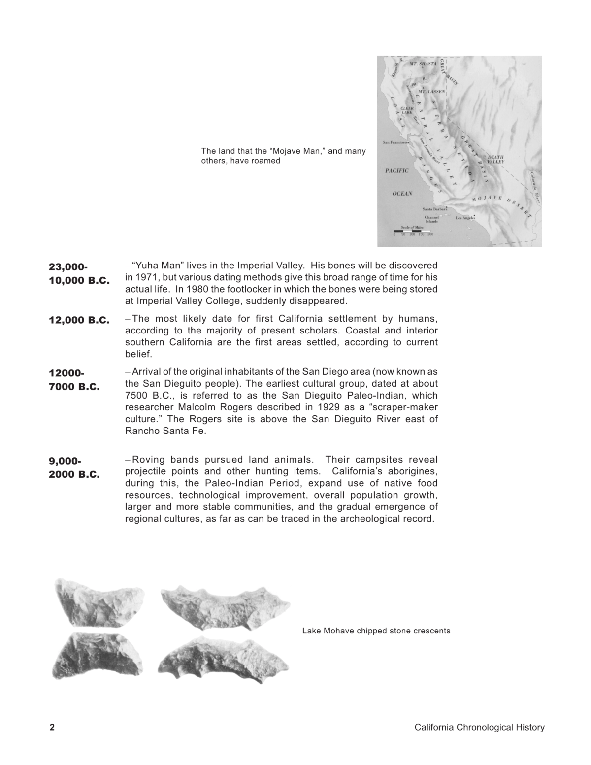
“Mojave Man,” “humankind of some sort,” inhabits the Mojave Desert, in the
Calico Hills, just northeast of present Barstow, according to carbon-dated and
magnetic examinations of stone artifacts, begun in 1964 by the renowned British
Archeologist Louis B. Leaky, and Ruth DeEtte Simpson, Curator of Archeology at
San Bernardino County Museum in Redlands. Their findings remain
controversial and work continues on the site.
68,000 B.C
“Del Mar Man” possibly lives at this time. His bones will be found in the late
1960s, but inadequate dating techniques for bones that old will make the find
controversial. He may have existed as late as 6,000 B.C.
35,000-12,000 B.C
Scattered bands of game hunters (perhaps ancestors of American Indians)
migrate from the Asian Steppes, across the then exposed Bering Straits, or by
boat, hopping Northern Pacific Islands, according to one group of archaeologists.
Some wanderers may reach California at the end of this period.
38,000-8,000 B.C
Tar pits at what would become Rancho La Brea (now a 32-acre site in Hancock
Park, in the Wilshire District of Los Angeles) trap evidence of Pleistocene or Ice
Age animals and plants. The last glacier retreat causes a sodden marshland
followed by aridity, according to Bones found dating from near the end of this
period. The great Ice Age mammals become extinct.
23,000-10,000 B.C
“Yuha Man” lives in the Imperial Valley. His bones will be discovered in 1971,
but various dating methods give this broad range of time for his actual life. In
1980 the footlocker in which the bones were being stored at Imperial Valley
College, suddenly disappeared.
12,000 B.C
The most likely date for first California settlement by humans, according to the
majority of present scholars. Coastal and interior southern California are the first
areas settled, according to current belief.
12000-7000 B.C
Arrival of the original inhabitants of the San Diego area (now known as the San
Dieguito people). The earliest cultural group, dated at about 7500 B.C., is referred
to as the San Dieguito Paleo-Indian, which researcher Malcolm Rogers described
in 1929 as a “scraper-maker culture.” The Rogers site is above the San Dieguito
River east of Rancho Santa Fe.
9,000-2000 B.C
Roving bands pursued land animals. Their campsites reveal projectile points and
other hunting items. California’s aborigines, during this, the Paleo-Indian Period,
expand use of native food resources, technological improvement, overall
population growth, larger and more stable communities, and the gradual
emergence of regional cultures, as far as can be traced in the archeological record.
8,000 B.C
That people migrate to California across the Great Basin of the Southwest seems
as likely as migration southward along the coast, or through a glacier free pass in
Alaska, after crossing the exposed Bering Strait from Asia during the last Ice Age.
Village sites at water’s edge will during recent times be under several hundred
feet of water. The sea is considerably shallower in 8,000 B.C., due to much of it is
water being trapped in polar glaciers as much as two miles thick.
Santa Barbara Channel mariners build seaworthy plank boats and leave the
safety of known waters to explore San Miguel Island. There they live in caves, eat
abalone and mussels, and keep pet dogs, thousands of years before the pyramids
of Egypt.
Lake Tahoe is molded into its present form.
7000-1000 B.C
La Jollan Indians assimilate the original San Dieguito people (or evolve from
them). Today's La Jolla Beach and Tennis Club is neighbor to a major
archeological site from this period.
6,000-3,000 B.C
After 6000 BC there is a shift from animal to plant foods for California Indians.
Once established, this way of life lasts thousands of years in prehistoric
settlements of several hundred people on the south coast. Their sets of
implements, still quite rudimentary and remaining notably constant, strongly
feature handstones and mills, underscoring the importance of seed gathering and
grinding. Food remains and other categories of artifacts show that the
subsistence also included hunting, fishing, and shellfish collecting.
3,000 B.C
Specialized and selective exploitations of particular environments begin to
evolve. They depend on a combination of hunting, fishing, and collecting, with
one activity or another receiving greater emphasis, depending on resources
available in particular areas. Mortars and pestles are added to milling stones and
mullers for processing plant foods. Chipped and flaked-stone objects are more
skillfully made and varied. Bone implements and shell ornaments increase in
number.
2,000 B.C
There are no large-scale climatic disruptions. The chief reasons for cultural
variance in the several regions, besides “normal” change through time, are based
upon differing cultural adaptations to regional environments.
1,500 B.C
Seafood is exploited by California’s first people.
500 A.D.
The bow and its lighter tipped arrows probably are introduced to California’s
natives. Whatever the implements used, hunting of land and sea animals
remains important throughout this period.
Yuman and Shoshonean Indian groups migrate to northern San Diego area.
Shoshoneans occupy almost a third of California.
1510. After Garcia Ordonez de Montalvo publishes his romantic novel, Las
Sergas de Esplandian, Spanish navigators become familiar with both the legend
and the fictitious name “California.” A passage in the work reads: “Know that,
on the right hand of the Indies, there is an island called California, very near the
Terrestrial Paradise.” It was populated by a tribe of fierce Amazon women that
allowed men among them but once a year, to procreate the species.
Spanish dominion in the New World is extended to the western coast of Mexico
by Cortes’ conquest of’ the empire of Montezuma.
1532. In an attempt to push Spanish domination farther west and north, Cortes
sends two ships commanded by his kinsman, Diego Hurtado de Mendoza, on a
“voyage of discovery” in 1532. Mendoza got as far into the Gulf of California as
27 degrees North, before a mutinous crew compelled him to send back one of the
ships. Of his vessel, nothing but vague rumor was ever heard again.
1533. Fortuno Ximenes, pilot of an expedition sent to search for Mendoza,
anchored in a small bay “near the 23rd degree of latitude,” lands, and is killed by
natives, along with 20 of his men. The survivors report the discovery of an island
(actually the Baja California peninsula), said to “abound in the finest pearls.”
1535. On May 5, Cortes enters the little bay that Ximenes had found (possibly
the present La Paz) and calls it Santa Cruz. He is convinced that it lays “on the
right side of the Indies,” if not “near to the Terrestrial Paradise,” For more than a
year, Cortes stays in the new land, a desolate sandy waste, while the mutinous
soldiers curse “him, his land, his bay, and his discovery.”
At first, “California” meant the peninsula on the west coast of modern Mexico
now known as Baja California or Lower California, and the Spaniards believed
that they had discovered an enormous island. Only as they ventured further
inland did they find that “California” extended north to join the continent, and
they named this northern extension “Alta California,” the region that now forms
the 31st state of the United States of America.
1537. The colony founded by Hernando Cortés on Lower California at Santa
Cruz fails and is abandoned.
1539. Hernando Cortes, clinging tenaciously to his search for the “seven cities of
Cibolo” in the north, sends three ships under command of Francisco de Ulloa to
begin a thorough survey of the coastline. Ulloa examines both shores of what he
calls “The Sea of Correa,” now known as the Gulf of California, or Sea of Cortez.
He misses the mouth of the Colorado River, but discovers that Correa Island is
really a peninsula.
Later the same year, it is said, he sailed around Cape San Lucas and surveyed the
Pacific coast line of the peninsula, traveling as far as the 28th degree. Some say
Ulloa sailed as far as “Cape Engano, near the 30th degree.” By this time, however,
Cortes had gone back to Spain, never to return. An ample food supply,
temperate climate, and absence of wars contributed to a large, healthy population
of natives discovered by these first Europeans. The aboriginal population at that
time was probably about 330,000, some 13 percent of the indigenous peoples in
North America.
Francisco Preciado, a Franciscan padre and diarist of the expedition of Francisco
de Ulloa, uses the name “California” many times in his account of Ulloa's
expedition, the first time the name appears in print as applying to an actual body
of land. He discriminates between “Isle of California” and “Land of Santa Cruz”.
1540. Hernando de Alarcón, a Spanish-American navigator, employed by Don
Antonio de Mendoza, viceroy of New Spain, is the first European to touch
California soil and, entering the Gulf of California, ascends the Colorado River
for more than one hundred miles on an expedition of discovery, cooperating
with Coronado.
1541. Domingo del Castillo, one of Alarcón's pilots, re-explores the Gulf of
California and charts its shores. He publishes a notable map of the Gulf of
California and the Colorado River which is recognized as both accurate and
authoritative. He describes California as a peninsula.
1542. Juan Rodrguez Cabrillo, a Portuguese navigator, is employed by Pedro de
Alvarado, Governor of Guatemala, for a voyage to the north under the flag of
Spain. Alvarado dies before the voyage is commenced, but Cabrillo is confirmed
by Mendoza, the new viceroy, who puts Cabrillo in command of the ships San
Salvador and La Victoria, “to examine the western side of California as far
northward as possible, seeking particularly rich countries and passages leading
towards the Atlantic.”
Cabrillo sails from Navidad, a small port in Jalisco, on June 27. Slowed by
adverse winds, he finally enters “a very good closed port” on September 28,
which he names San Miguel, the bay of present San Diego. He discovers Santa
Monica Bay and the three large islands of the Santa Barbara group, and then
rounds Cabo Galata (Point Concepcion) and Cabo de los Reyes (Point Reyes).
The ships pass the Golden Gate without seeing it.
On the way back, they find the harbor in the island of the Santa Barbara group,
which they name La Posesion. Catalina Island (proper name: Santa Catalina
Island), is discovered by Cabrillo, and is then is to be named in 1602 by Spanish
explorer, Sebastian Viscaino. Catalina is a 21-mile-long, 8-mile-wide island, 29
miles out from Los Angeles harbor. Part of a set of several islandsforming the
Santa Barbara Channel, the Southern Channel Islands include Santa Catalina, San
Clemente, and San Nicholas; the Northern Channel Islands include Santa Cruz,
Santa Rosa, and San Miguel. Catalina has been inhabited for at least 7,000 years,
beginning with Native Americans of the Takic branch of the Uto-Aztecan
linguistic family.
Alonzo de Santa Cruz, the cosmographer royal of Charles V of Spain, publishes a
map showing California to be in the lower part insular and in the upper part
peninsular.
1543. Juan Cabrillo dies on the small windswept island of San Miguel, the
northernmost of the Santa Barbara group. The command is passed to his pilot,
Bartolome Ferrelo, who sails north again, the ships reached a promontory on
February 26, probably Cape Mendocino, which Ferrelo names Cabo de Fortunes
(Cape of Perils or Stormy Cape). Turning back, they eventually return to their
homeport of Navidad.
Disappointed by reports of the expedition, Spanish officials are more and more
convinced that north of Mexico the New World contains “neither wealthy
nations, nor navigable passage between the Atlantic and Pacific Oceans.” Later,
when treasures of the Orient begin to come into the port of Acapulco from the
Philippines and from China, Spain finds the long continental mainland provides
the best protection of its inland sea from the Pacific.
1579. England’s sailors have no way into the Pacific except by rounding Cape
Horn, the southern tip of South America. Francis Drake does so in his 100-ton
schooner, the Golden Hinde, which he anchors on June 17 in what will become
Drake’s Bay, most likely today’s Point Reyes.
He claimed it for Queen Elizabeth and named the region New Albion. Drake had
landed along the coast of Miwok Indian territory, and lived among these friendly
natives for five weeks. Drake mistook their ceremonies and hospitality as
conferring some kind of religious veneration upon himself and his crew, and
departed feeling rather good about his accomplishments.
Drake orders religious services, the first Christian rites in California, to be
performed with the Indians as witnesses in order to convey to their minds the
idea of “everlasting God who created heaven and earth and reigned above.” It is
undeniably a Protestant service.
1584. Drake’s visit seems to have aroused Spain’s dormant interest in California.
In 1584, Francisco deGali makes a much more thorough examination of the
California coast than had Cabrillo 42 years before.
Under command of Viceroy Pedro de Moya de Contreras, de Gali starts from a
port of New Spain, crosses the Pacific Ocean of Alta California, and then
southward along the coast, close to the islands along the California shores. He
discovers the Japan Current, thus making an easy return trip from the Philippine
Islands to Mexico. This has an important impact on California, as it becomes
critical to Mexico’s trans-Pacific shipping needs. It is this that causes the King of
Spain to desire California, and not her own worth, as that is never known or
appreciated by Mexico’s rulers.
1588. “The Silver Map of the World” appears, which is assumed to be “A
contemporary medallion commemorative of Drake's voyage (1577-80)”, and on
this map is engraved “Californoa”.
1595. Sebastian Cermeno is directed, while returning from Manila to Acapulco,
to examine the California coast, “in search of harbors in which galleons might
take refuge.” After losing his own ship somewhere “near San Francisco Bay south
of Cape Mendocino,” he sails in a small boat southward along the coast, and
sights the Bay of Monterey, which he names “San Pedro Bay.”
1597. Gonzalo de Francia, boatswain of a ship under Sebastian Vizcaino, visits
Santa Cruz Bay and later (1629) writes to the King: “We came upon un puerto
grande which was called El Puerto de la Paz, - and an island at the mouth of it
which was called Island of Women, who were without men, none passing over
them except in summer on rafts made of reeds.”
1600-1700
1600. An excellent map is published by Tattonus, showing Lower California as a
peninsula. The early cartographers persist in the insular idea. From 1541 (the map
of Castillo) to 1622 the peninsula idea gains ground, but again from 1622 to 1746 a
reaction toward the idea of California being an island prevails, even against the
distinct proof to the contrary in Kino's entradas.
1602. With three ships “well officered,” Sebastian Vizcaino makes a second
attempt to explore the coast of California, sailing as far as Cape Mendocino. The
first harbor he reached, “the best in all the South Sea,” he renames it San Diego de
Alcala, from the earlier San Miguel Bay. On November 12, Carmelite friars of his
party celebrate Holy Mass ashore for the first time in Upper California. Vizcaino
spends almost the entire year in the survey but, like Cabrillo, he misses the
Golden Gate. He renames many places named by Cabrillo in 1542, among them
San Diego, Santa Catalina, Santa Barbara, Point Concepcion, the Carmel River,
and Point Reyes. He also names Monterey Bay, in honor of the viceroy, Gaspar
de Zunigay Acebedo, who is the Count of Monterey.
1603. Sebastian Vizcaino publishes maps showing the Port of Monterey and the
San Francisco Bay of Cermeño (Puerto de los Reyes). This latter bay is also
identical with Sir Francis Drake's Bay.
1604. “Zinogaba” Indians are mentioned by the Mojave Indians to Juan de
Onate in 1604 as a tribe of people with bald heads, living on an island of the same
name a day's journey by boat off the California coast. These Indians are said to
wear necklaces and ear ornaments of pearl shells, called xicullo (shi-kul-yo), and
to possess “an instrument with which they make the noise when they dance,
which is a long stick from which are pendent many pieces of that metal (silver) of
which they make dishes in which they eat.”
The tribe had an old “lady or captainess,” called Cinacaco-hola, “the height of a-
man-and-a-half,” very broad, with big feet, and who has a sister, also a giantess.
There are no men of their kind, and the sisters mingle with no one on the island.
1609. King James I of England makes his second grant of land on the North
American Continent, in Virginia, known as the Jamestown Charter, dated May
23, 1609, the seventh year of King James' reign. The island limit of this grant or
charter is from sea to sea, that is, from the Atlantic to the Pacific, the southern
boundary 38 north latitude. His final northerly limit passes into the Pacific
Ocean, just north of San Francisco and the southern limit passes about three miles
south of what is now the city of Redlands, California, through the city of
Riverside, and into the Pacific Ocean at about the point where Santa Monica,
California is today, so that all of the Pacific Coast line from Santa Monica to the
Golden Gate Bridge is the westerly limit of this Jamestown Grant, though never
to be legally established or right of control exercised.
1610-1670. After Vizcaino’s visit, Spain’s efforts are largely spent in attempts to
colonize New Mexico rather than Upper California, though recurrent attempts
are made to keep alive the pearl-fishing industry on the eastern coast of Baja
California.
1622. A map of “The World” by Kaspar Van Baerle appears, and on this
California is drawn as an island of great size and of rectangular shape. Other
maps from this year (and in succeeding years to 1746) replace the peninsula of
California by an island.
1683. Don Isidro de Atondo places settlers, soldiers, and Jesuits at different
points, planning a steady penetration of California. But the project lags, and not
until 1697 will Jesuits receive royal warrants to enter upon the reduction of
California at their own expense.
1697. October 25. The Jesuit Mission System begins in Baja (or Lower)
California, under Fathers Eusebio Francisco Kino, missionary and royal
cosmographer, and Juan Maria de Salvatierra, Assistente at Los Chimpas, as
Visitador. The first mission, Loreto de Concho, is founded at Loreto.
1700-1800
1701. August 19. Thirty miles south of present Mexican border, Father
Francisco Palou sets a cross to mark the boundary between Baja and Alta
California. Father Kino crossed the Colorado River near Yuma, entered Alta
California, and worked among the Indians of “Pimeria Alta.”
1734. Vitus Bering pushes exploration of Alaska, and Spain begins to fear
colonizing activities of Russia along the Pacific coast.
1749. Father Junipero Serra is sent to Mexico as a missionary.
1750. Oil from hand-dug pits in Los Angeles is distilled to produce lamp oil by
General Andreas Pico.
1754. A new peril arises for Spain’s interest in California when France is swept
from sovereignty in America by Britain. Spain can put off no longer the
settlement of Alta California.
1757. Miguél Venegas, a Mexican priest, publishes in Spain his history of
California, Notica de la California. This work will be translated into English,
Dutch, French and German, and will become the basis of all later histories. In it
Venegas says he thinks the word California originates from two Latin words
calida and fornax, meaning hot furnace, though he doubts the Spanish
adventurers “had so much learning”. He also suggests that the origin may be an
Indian word, possibly kali forno, meaning high hill.
1766. A high officer of the Spanish “Council of the Indies,” Jose de Gaivez, is
sent to Mexico City as Visitador General. His main duty is to increase Spanish
domination and profit from the Californias.
1767. The Jesuit priests are expelled from Mexico. Their missions in Baja or
Antigua California are turned over to the Franciscan order, which is charged with
expanding their influence into Alta California.
1768. Franciscans take over Jesuit missions in Baja California.
1769. July 28. Conquest of Upper California is ordered and committed to Don
José Gálvez, the Visitador General of Mexico and San Francisco de Croix, Viceroy.
Captain Gaspar de Portolá is made civil and military commander of the country,
and Fray Junipero Serra, Father President of the missions. The “Sacred
Expedition” ordered by the Spanish Viceroy, is shaken by an earthquake as it
travels near present Los Angeles. This is California’s first historical earthquake,
estimated to have been of 6.0 magnitude on the Richter Scale.
1769. January 9. The Spanish ship San Carlos leaves LaPaz. Two days later,
the San Antonio sails from San Lucas. Soon after, the Senor San Jose sails from
Loreto. The vessels are loaded with ornaments, sacred vases, church vestments,
household utensils, field implements, seeds, and other settlement needs.
March 24. Captain Fernando Rivera y Moncada departs Velicata, near the
present site of San Rosario, leading a land party of 25 soldiers, 3 muleteers with a
packtrain of 180 mules. With Franciscan Father Juan Crespi and about 50 Indians,
they hike the rugged desert trail up the Baja peninsula. Father Junipero Serra
departs from Loreto Mission March 28, suffering from a painful leg infection.
April 11. The San Antonio, under Captain Juan Perez, reaches its destination of
San Diego Bay, and the San Carlos does the same on April 29. However, scurvy
had swept both vessels, ravages on the San Carlos had so prostrated the crew that
not even a boat could be lowered.
The San Antonio’s boats carry the sick ashore, where they convalesce behind a
temporary stockade. The march by land is no less long and painful. Forces are
divided into two columns, one under an army captain, Fernando de Rivera, and
the other under Portola. With the latter goes Father Serra. The columns take
different routes, each driving a herd of cattle.
May 5. Father Serra joins Captain Gaspar de Portola at the frontier mission of
Santa Maria. They travel to Velicata and depart for San Diego on May 15, with the
second land party.
May 15. Rivera’s party reaches San Diego. Portola’s route is more difficult, and
his party does not arrive until July 1. The expedition loses no time in putting
plans into action. Mission San Diego de Alcala is dedicated on July 16, two days
after Portola leads sixty-four members of the expedition away to the north to find
the Bay of Monterey. The newcomers, Spanish officers in brilliant uniforms,
monks in gray-brown cowls, leatherclad soldiers, and Indians on foot, trek
through country described by Portola as “rocks, brushwood and rugged
mountains.”
July 14. Starting from San Diego is an expedition under the command of
Portola, sixty-seven soldiers, friars and artisans, traveling northward to find the
Bay of Monterey, the real objective of the whole expedition. In the company is
Sergeant Jose Francisco de Ortega, who while hunting will first discover San
Francisco Bay.
July 16. Mission San Diego de Alcalá founded. There has been much discussion
as to the origin of the name. The Bay is named San Diego, simply for Vizcaino’s
flagship, but the mission is named by Serra after the saint whose day it was, and
not Santiago (San Diego) de Compostella, patron saint of Spain, as will often be
said.
October 2. Upon reaching Monterey, Portola’s group fails to recognize it and
pushes on. In Father Crespi’s words: “The expedition strove to reach the Punta
de los Reyes, but some immense arms of the sea which penetrate into the
mainland in an extraordinary fashion would have made it necessary to take a
long, circuitous detour,” Those arms of’ the sea first seen by Sergeant Ortega and
his band of scouts are the reaches of San Francisco Bay. Inept at foraging for
food, the company almost starves, eating 12 of their pack animals in as many
days.
San Francisco Bay is given this name for the first time, although still with the idea
that it was the Saint Francis Bay of Cermeño.
California’s first road, El Camino Real, is established, connecting the Missions
system.
1769-1771. Matas de Armona is the first Spanish governor of California.
1770. January. Anacapa Island, most barren of the four Santa Barbara Islands,
30 miles off the Southwestern California coast from Point Conception, is
discovered by the Portola expedition. The name is derived from Chumash Indian
word anyapah, meaning “unknown.” It was once volcanic. The mountainous,
three-segment island Originally it was settled by Chumash Indians, who were
killed in great numbers by the Russians and Aleuts, who used the island as a base
for fishing and seal and otter hunting.
January 24. The Portola expedition returns to San Diego, “smelling frightfully
of mules.” At San Diego, there is so much suffering from illness and hunger that
Portola decides to abandon the expedition and return to Baja California if help
does not arrive from Galvez by March 20.
March 19. A sail is sighted on the horizon, and less than a month later the
expedition is on its way back to Monterey. This time they recognize the bay on
March 31. Captain Juan Perez anchors his ship San Antonio in Monterey Bay
and on July 9th the second mission and presidio of San Cárlos Borromeo de
Monterey is founded, the second mission and the first precidio, or fort. It
becomes the first capital of California.
June 3. The sites of the mission and the presidio are dedicated. Serra feels they
are dedicating themselves to the task of civilizing the natives and winning them
for God. To Portola, the planting of royal standards and crosses in the name of
King Carlos III of Spain signifies the assertion of more missions being established,
and near some of them, presidios and pueblos.
The missions form a chain of civilized outposts along the coast, spaced a day’s
journey apart. Each has its herd of cattle and its field and vegetable gardens
tended by Indian neophytes. The Indians, taught by the padres to build
irrigation systems, also become weavers, masons, carpenters, and blacksmiths.
Thus the missions are nearly self-sustaining. The work of the padres, measured
by the number of Indians reclaimed from their free life in the wilderness and put
to tilling fields, was for a time successful.
Eusebio Francisco Kino, a missionary of Sonora, makes a final entrada to the
Colorado, following it as far north as latitude 35, proving that California is not a
peninsula.
June 3. Establishment of San Carlos Borromeo de Carmelo (Carmel) at present
Monterey.
1771. Father Serra moves Mission San Carlos Borromeo de Carmelo to Carmel to
prevent further liaisons between his female Indian converts and the Spanish
soldiers at Monterey.
July 14. Establishment of Mission San Antonio de Padua.
September 1. Establishment of Mission San Gabriel Arcángel.
1771-1774. Felipe de Barri serves as the second Spanish Governor of California.
1772-1773. Father Serra travels to Mexico City to denounce Fages and ask for
more support for his missions.
1772. September 8. Establishment of Mission San Luis Obispo de Tolosa. It
becomes a supply center for bear meat.
Pedro Fages leads expedition to explore San Francisco Bay region. His party
become the first white men to see the Sacramento and San Joaquin River Valleys.
1773. New Spain Viceroy Antonio Mara Bucareli y Ursa authorizes the military
commanders of San Diego and Monterey to assign land to Indians and new
colonists. The boundary between Alta and Baja California is set 30 miles south of
the present border between Mexico and the United States.
1774. March 22. Juan Bautista de Anza reaches San Gabriel Mission from
Sonora by overland route. He then marches, in company with Fray Garcés, north
to Monterey, trying to open a practical overland trail from the California missions
to Mexico, through Arizona.
San Diego de Alcalá moved to present site.
Dec 24. A woman of Anza’s party of colonists, en route from Sonora to San
Francisco, gives birth to Salvator lgnacio Linares, first non-Indian born in
California.
1775. Mission San Gabriel Arcángel is moved to a new site five miles east of the
original.
March 28. Juan Batista de Anza reaches site of San Francisco with 240
immigrants brought from Sonoma and Tubac, Mexico, establishing a presidio
along the Golden Gate. Having left Tubac in October, Anza led them over the
present Arizona desert and the snows of the high Sierra, arriving with his
company almost intact after first stopping in Monterey. Only one person, a
woman, died on the way, and eight children were born enroute.
Jun 27. San Francisco, although an adjunct to the Presidio, is planned by the
Spanish authorities as a civic enterprise.
August 1. Juan Manuel de Ayala, in his ship San Carlos, enters San Francisco
Bay.
August 16. By royal decree, Monterey becomes the capital of Alta California.
September 17. Led by Jose Joaquin, the Presidio of San Francisco is dedicated.
October 9. The seat of government is transferred to Monterey by Governor
Felipe de Neve, Governor.
November 1. Mission San Juan Capistrano is formally founded by Father Serra;
pueblo status is granted to the civilian community living around the mission.
November 4. Mission San Diego is destroyed in one of the earliest and most
successful demonstrations of native resistance to colonization. Under the
leadership of the native neophyte Francisco, of the Cuiamac Rancheria, the lpai-
Tipai Indians organizes nine villages into a force of about 800 men who not only
completely destroys the mission but also kills three Hispanos including Padre
Jaume. Survivors withdraw to the presidio six miles west. Questioned after the
rebellion, one Indian leader says he wanted to kill the priests and soldiers “in
order to live as we did before.”These Indians will not be pacified until late 1776.
Juan Bautista de Anza explores a land route between San Diego and Sonora,
Mexico.
Manuel Burton, a soldier in the Monterey garrison who married a Costanoan
Indian woman, receives the first land grant in Alta California, a plot in the
Carmel Valley.
A trail blazed between Santa Fe, New Mexico, and the Colorado River,
California’s eastern border, Eventually it will end near Los Angeles, and become
an important travel route between the Southwest and Southern California, known
as the “Spanish Trail.”
1775-1782. Felipe de Neve, (1728-1784), serves two terms as the Spanish
Governor of California.
1776. Mission Indians revolt at San Luis Obispo de Tolosa. The raiders destroy
the log buildings by shooting flaming arrows into the thatched roofs.
June 29. Establishment of San Francisco de Ass (Mission Dolores), by the Arroyo
de las Dolores (Our Lady of Sorrows Creek), in present San Francisco.
July to October. Father Serra returns to San Diego aboard the San Antonio on
July 11. Mission buildings are rebuilt with the help of Indians and sailors from
the San Antonio who make adobe, dig trenches and gather stones.
King Carlos III of Spain issues a decree banishing all Jesuits from Spanish
territories, Franciscans are to take over the mission at Loreto, which is to be the
base of the operations, both military and pastoral. Captain Gaspar de Portola is
appointed Governor of Baja California and ordered to proceed to Loreto to
superintend the transfer of mission property, He reaches Loreto with an escort of
fifty soldiers, accompanied by fifteen Franciscan monks, and is joined by Galvez
and Father Junipero Serra, President of the missions in California.
The king orders Galvez “to send an expedition by sea to rediscover and people
the bays of San Diego and Monterey.” Galvez thinks it well to send a land
expedition, and Father Serra agrees. Three missions in Alta California, at San
Diego, Monterey, and at an intermediate point, are to be established, as well as
two presidios or military posts.
September 17. Founding of the Presidio of San Francisco de Asis by two
Franciscan monks, Palou and Gambon.
October 4. The mission of San Francisco de Asis, five miles or so away from the
presidio, is founded on a small creek called Dolores. Hence the mission is
commonly known as the Dolores Mission. Fathers Palou and Gambon assume
charge of this, the sixth such mission.
James Cook makes the last of his four voyages under the English flag. It is this
fourth voyage that is of special interest to California. He sails by the way of the
Cape of Good Hope and discovers the Hawaiian Islands. He reaches California at
Cape Mendicino and skirting the coast to the north discovers Nootka Sound, thus
laying the foundation for the Nootka Controversy at a later date, and sails
through the Bering Straits as far north as Icy Cape. Cook dies on the voyage but
on the return, while at Canton a discovery of great historic and commercial value
is made when the supposed valueless furs, which had been traded for knives and
trinkets with the Indians of the Nootka Sound vicinity, bring fabulous prices in
China. This lays the foundation for the future great fur trade.
1777. January 12. Establishment of Mission Santa Clara de Ass on the banks
of the Guadalupe River.
August 28. Mission of Santa Cruz is founded.
November 29. San Jose de Guadalupe, first pueblo in California, is founded
by Governor Felipe de Neve on the Rio de Guadalupe. The colonists consist of
fourteen heads of families, sixty-six persons all told. They are granted house lots
and planting lots and free use of the public grazing fields, under charter of the
pueblo system. The lands could not be sold nor mortgaged. The colonists are free
from taxes for a number of years and are furnished a certain number of domestic
animals and seeds. The government is under an alcalde, or magistrate, and a
council is elected yearly.
The first major epidemic of the Spanish occupation is reported at Mission Santa
Clara, and believed to be respiratory in nature. It causes great losses among the
captive natives.
1779. June 1. Governor Felipe de Neve drafts regulations for government of
California.
Flooding of the Guadalupe River forces the relocation of Mission Santa Clara de
Ass.
1780. Reconstruction of Mission San Diego de Alcalá.
September 4. City of Los Angeles is founded (El Pueblo de Nuestra Senora La
Reina de Los Angeles del Rio de Porciuncula, meaning City of Our Lady, the
Queen of the Angels). At the beginning there are eleven heads of families, forty-
six persons all told. Los Angeles is the second of the early pueblos
The military commander of the Sonora district determines the establishment
among the warlike Yuma two garrison posts with colony and mission
attachments, despite the protests of the missionaries concerned, who foresee that
the combination would be disastrous to their own part of the work. Two sites are
selected, however, in the fall of the year on the west bank of the Colorado: the
first, La Purisima Concepcion, is to occupy the site of old Fort Yuma; the other,
San Pedro y Pablo de Bicuner, is 8 or 10 miles lower down, possibly just across
the present Mexican border. Purisima mission is placed in charge of Father
Francisco Garces, the explorer, with Father Juan Barreneche as his assistant, while
the other is given over to Fathers Diaz and Moreno.
The Yuma Indians at old Fort Yuma and San Pedro y Pablo de Bicuner are roused
to hostility by the methods and broken promises of the military commander. In
July, both settlements are attacked almost simultaneously, the buildings
plundered and burned, the commander and every man of the small garrison
killed after a desperate resistance. The four missionaries and nearly all the men
of the colonies are also butchered, and the women and several others are carried
off as captives. A subsequent expedition rescues the captives and bury the dead,
but the Yuma remain unsubdued and the colony undertaking is not renewed.
1782. March 31. Mission of San Buenaventura is founded by Father Junipero
Serra.
April 21. Pueblo Santa Barbara is established by Governor Felipe de Neve and
Captain Jose Francisco Ortega, with Father Junipero Serra.
1782-1791. Pedro Fages, (1730-1794), serves as Spanish Governor of California.
1784. August 28. Father Serra dies, and is buried at San Carlos Borromeo
Mission, in present Carmel.
Construction of new chapel at Santa Clara de Ass.
1785. Governor Lieutenant Colonel Fages, Governor of Alta California, receives
a legal opinion which upholds his right to grant lands to soldiers as long as those
lands lay outside the four square leagues owned by pueblos and did no harm to
mission or Indian holdings.
Although mission authorities opposed such colonizing by individuals, Governor
Fages is empowered to make private grants for outfitting each ranchero with a
storehouse and at least 2,000 head of cattle.
1786. Father Fermin Francisco de Lausuen, who succeeds Father Junipero Serra,
founds Mission Santa Barbara.
A discerning French scientist, Jean Francois Galaup de la Perouse, visited
California and wrote that he was not impressed with what the padres were
doing. He doubted whether the mission system would ever develop self-reliance
among the aborigines. Whipping with barbed lashes, solitary confinement,
mutilation, use of stocks and hobbles, branding, and even execution for both men
and women, characterized the “gentle yoke of Catholicism” introduced to save
the heathen souls for Jesus. Father President Fermin Francisco de Lasuen
rationalized such cruelties this way: “It is evident that a nation which is
barbarous, ferocious and ignorant requires more frequent punishment than a
nation which is cultured, educated and of gentle and moderate customs.”
Like the missions and most other buildings in colonial California, the presidios
are being built with free native labor provided by the neophytes and prisoners.
As soldiers’ families begin to acquire Indian servants, this ultimately fosters the
development of a gente de razon ruling class of Hispanos served by a mass of
native slave laborers.
1787. From the native viewpoint the Spanish invasion and occupation is an
immensely huge catastrophe. Coastal natives are rapidly reduced by disease and
sickness introduced by being concentrated in unhealthy mission environments,
far different from their native village life. Crammed mission housing causes the
rapid spread of contagious diseases.
Christianization, for many inland tribes, means relocation from warm interior
weather to the cool damp coastal region. Indians in California, like Indians
throughout the Americas, are highly susceptible to most European diseases; and
contact between the two races almost inevitably results in a high native death
rate.
1788. The Gabrielino Indians, under the leadership of a medicine woman named
Toypurina, are thwarted in an attempt to destroy Mission San Gabriel. The
Indians from Missions La Purisima and San Luis Obispo together plot a revolt
that is discovered by the missionaries, resulting in several arrests and
punishments
1789. June 13. Establishment of Mission San Luis Rey de Francia.
1790. March 26. The United States Congress, through the act of 1790, decrees
that “any alien, being a free white person who shall have resided within the
limits and under the jurisdiction of the United States for a term of two years, may
be admitted to become a citizen thereof.” The phrase “free white person” remains
intact until 1873 when “persons of African nativity or descent” is added. This act
would be used to deny citizenship to Japanese and other Asian immigrants until
the mid-twentieth Century. Perhaps most affected will be the future State of
California.
1791. August 28. Mission Santa Cruz is founded by Father de Lasuen.
October 9. Mission Nuestra Senora de La Soledad is founded by Father de
Lasuen.
1791-1792. José Antonio Roméu (1742-1792), serves as Spanish Governor of
California.
1791-1805. Construction of Mission San Gabriel Arcángel.
1792. September 13. John Groeham (Graham), first American in California,
reaches Monterey. He is ill when he arrives and dies the same day.
November 14. Captain George Vancouver, in the British sloop Discovery,
reaches San Francisco. It is the first of three visits he makes to California.
1792 - 1794. José Joaqun de Arrilaga (1750-1814) serves as Spanish Governor of
California.
1793. Pueblo of Branciforte is founded on site of present Santa Cruz.
December 14. Raiders from the village of Quiroste, near Point Año Nuevo,
attack Mission Santa Cruz, wounding some of the guards and burning the
guardhouse and lamb corral. It is the only attack ever made on a northern
mission.
1793-1797. Construction of present sandstone church at Mission San Carlos
Borromeo de Carmelo.
1794-1800. Diego de Borica (1742-1800) serves as Governor of California.
1794. January. Soldiers are dispatched to Santa Cruz from the San Francisco
and Monterey presidios, taking captive eight Indians. The leaders are shackled
and eventually sent to the San Diego Presidio where they will die in 1798.
Original chapel at San Carlos Borromeo de Carmelo replaced by a larger
structure. Engineer Miguel Costanso advises that California needs better
presidios, and his attempt to find a location for a new town near San Francisco is
unsuccessful.
Construction of El Castillo de Monterey.
Governor Diego de Borica condemns the treatment of Indians at the Franciscan
missions.
1795. Over 200 Costanoan Indians escape Mission Dolores in San Francisco.
Most will later turn to active resistance to insure their freedom. They introduce
Spanish horses, weapons, and military tactics to the unconverted interior tribes,
and convince them to resist being enslaved by the Catholic Church.
Manuel de Vargas, pioneer school teacher, opens the first public school in San
Diego.
1796. October 19. The American vessel Otter, captained by Ebenezer Dorr, is
the first American ship in California waters, and lands at Monterey with ten men
and a woman, escapees from Australia’s Botany Bay penal colony. Spanish
officials are furious until they learn that the men are skilled artisans. Other
Yankee trading vessels would soon begin probing the Spanish waters of
California.
1797. June I8. Mission of San Jose de Ia Guadalupe is established.
June 24. Mission of San Juan Bautista is founded. Pueblo status is granted to
settlers in area.
July 25. Mission of San Miguel Arcangel is established.
September 8. Mission of San Fernando Rey de Espana is established.
Completion of chapel at Mission Nuestra Señora de Soledad. It will be washed
out several times by Salinas River floods.
Publication of Father Junipero Serra’s biography by his friend, Father Francisco
Palóu.
Establishment of Branciforte Pueblo near Santa Cruz. Tensions between the
mission community and the settlers will mount through the years.
Mission San Diego becomes the most populous in California with 1,405 Indians.
1798. June 13. Mission San Luis Rey de Francia is founded by Father Fermin
Francisco de Lasuen. The 18th of the 21 California missions, it is named after
Saint Louis IX, King of France. It will grow quickly to become the largest mission
with a peak population of nearly 3,000 during the 1820s.
Construction of chapel at Mission San Juan Bautista, near present Hollister.
Padre Antonio de la Concepcion Hoffa of Mission San Miguel enrages his fellow
servants of God by reporting to the Viceroy in Mexico that the Franciscan Order
in California is guilty of cruelty and mismanagement of Indians in their
jurisdiction. Hoffa charges: “The treatment shown to the Indians is the most
cruel I have ever read in history. For the slightest things they receive heavy
floggings, are shackled, and put in the stocks, and treated with so much cruelty
that they are kept whole days without a drink of water.”
The unfortunately outspoken padre is quickly isolated, declared insane, and for
the sake of the Lord’s work, is taken out of California under armed guard,
suffering treatment similar to that of whistle-blowers even today.
1799. The American ship Eliza stopping at San Francisco for a little illicit
trading, is frowned upon by Spanish authorities.
(Read More)
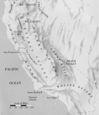
The land that the “Mojave Man,”
and many others, have roamed.